 | ||||||
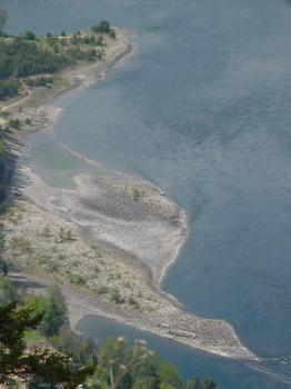
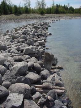
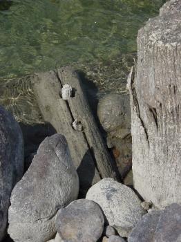
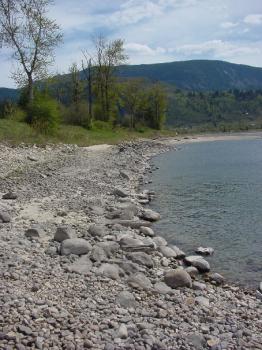
Tin Cup RapidsThe double rapids above the mouth of the Kootenay River are today known as the Tin Cup Rapids, a name reminiscent of the fur trade. Regular travel through this area commenced in 1811 when David Thompson implemented the Athabasca Pass route across the Rocky Mountains. Although freighting along this route ceased in a few years when ocean transport via the Pacific was adopted, the Columbia remained as the transcontinental route for scheduled Express runs for four decades. For voyageurs following the Columbia between Fort Vancouver and Boat Encampment, the local rapids were only a minor inconvenience when compared to the notorious Death Rapids north of Revelstoke. The Columbia rapids together claimed at least sixty-eight lives when the voyageur canoes ran the river.When steamships started working the river, the Kootenay Rapids - as they were then known - posed a serious obstacle to navigation, especially late in the year when water levels were low. Efforts were made to improve the river channel by blasting underwater obstructions and constructing a breakwater dike on the east shore to increase the depth of the water in the main channel. These efforts resulted in only a limited degree of improvement, so that by 1895 a new steamer dock was built below the rapids, at the mouth of the Kootenay. This dock served the Robson - Trail traffic during the low water period. After 1897, scheduled navigation of this stretch of the Columbia was suspended as the newly-built Columbia and Western Railway provided a land link between Robson West and Trail. It is not clear when and for what reason the current name was applied to the fast water above the mouth of the Kootenay River. The double set of rapids between the spot where the Columbia abruptly turns southward again and the point where it meets the Kootenay are today known as the Tin Cup Rapids. The name easily evokes the image of a voyageur dipping a drinking cup into the fast current and losing it in the process, but the true origin of that evocative label is still a mystery. The name is suggestive of simpler times, when flotillas of canoes plied the river. There is no record, however, of this name being used during the fur-trading period; in actual fact, the rapids are hardly mentioned in the early journals of the travelers that passed this strategic spot just above the confluence of two great rivers. Their presence was noted by some, however. David Thompson, in his exacting record of river courses and distances, describes the pair together as a "strong rapid". The entry is for September 6 1811, when he resumed his upstream passage again after spending the night near the junction of the two rivers. Alexander Ross, following in Thompson's footsteps fourteen years later fails to mention them at all, even though he is obviously a keen observer of his surroundings. He does, however, describe at some length a man-made feature in the Columbia near its junction with the Kootenay, which was dependent on their presence: [The entrance of the Kootenay River] " is rendered still more remarkable by a dike of round stones, which runs up obliquely against the main stream, on the west side, for more than one hundred yards in length, resembling the foundation of a wall; it is nearly as high as the surface of the water, and is clearly seen at low water. On the opposite or east side is a similar range, of less extent. These are evidently the work of man, and not destitute of ingenuity; we supposed them to be a contrivance for the purpose of catching fish at low water: they are something similar to those used by the Snakes during the salmon season. At the upper end, both ranges incline to the centre of the river, where they nearly meet." Ross is not very specific about the precise location of this remarkable structure, but he does provide a hint and he expresses his opinion that it was used to assist in fishing operations on the river. He describes the weir as a submerged dike of river rock, just visible through the water. Significantly, Ross states that this structure has a longer leg on the western portion of the river channel, and a shorter leg on the eastern side. The overall length is in the vicinity of 200 yards. One site which has been postulated for the structure is just below the confluence of the rivers, from Zuckerberg Island to the peninsula where Selkirk College is located. I do not support this location, as the river channel there is too deep for such a structure to be constructed, and too narrow to meet the measurement specifications provided by Ross. Furthermore, a structure in this location would be subjected to the full force of the combined river currents. For those reasons I advocate an upstream location for this remarkable structure. I believe it was located at the foot of the Lower Tin Cup Rapids. Here the river channel is wide enough (201 meters, vs. 160 meters at the lower location). Furthermore, the profile of the river bottom fits Ross' description, as the shallower portion of the lower rapids is on the western side; this would allow the construction of the longer leg of the weir out to a point where the water becomes impossibly deep. A shorter leg protruded into the deeper water from the eastern shore, and the central channel was most likely left unobstructed. During the right season, poles were embedded to the submerged barrier and reed mats were attached to these, in effect barring the upstream passage of salmon somewhat. Fish passage through the deeper areas were probably regulated by nets or the presence of boats, although, as was convention, a certain proportion of the fish were allowed to pass up the main stream. The structure thus functioned in two ways. Fishing baskets could be employed in the mats to catch trapped fish as they tried to ascend the Columbia. Perhaps even more important was the second function of the partial dam: it would divert a significant additional component of the migration into the Kootenay and Slocan rivers. The latter river was a prime fishing river, and there is a record of a battle being fought over this fishery between the Ktunaxa and the Sinixt. Fish were diverted into the Slocan by the relatively impassable barrier of the two Bonnington falls. The lower Kootenay River was also a prime fishing area because of the endless cascades and rapids where fish could be easily speared or caught in traps. The location upstream from the mouth of the Kootenay had other advantages. During the summer freshet, and under the natural flow conditions, the Kootenay River acts as a hydraulic dam when its forceful current cuts into the Columbia. The end effect is a slight backing up of the main river and a significant reduction in its current velocity. These factors would tend to preserve the underwater stone dikes in this setting. Evidence of this remarkable structure disappeared when sternwheelers started working the Columbia River, which was considered easily navigable between Little Dalles (below Northport) and Revelstoke. The local rapids became a headache, however, when river flows dropped dramatically in the autumn and winter. Various efforts were undertaken in the 1890's to make the passage of steamboats through the shallow water of the rapids easier. It is during this period that this stretch of water received a name which is in disagreement with the current nomenclature. They were referred to as the Kootenay Rapids, and the lesser rapids below the mouth of the Kootenay were called the Tin Cups. Efforts on improving steamer passage through the tricky rapids were carried out in two phases. In late winter of 1891, work commenced on widening the channel through the upper Kootenay Rapids by blasting away river obstructions. "On Monday a party of men commenced removing obstructions from the channel of the Columbia River at Kootenay Rapids, a mile below Sproat. The party is in charge of A. Lindquist, who was the mate of the steamer Lytton last season. The water in the river is said to be lower than usual for this season of the year." (Nelson Miner, Feb.14 1891) "The men engaged at removing obstructions from the Columbia River below Sproat are reported as making good headway. The obstructions in the first ripple or rapids are already nearly all removed." (ibid, Feb.21) The presence of the work crew at this location helped to save a life. As trains had stopped running for the winter season, R.S. Williams decided to snowshoe from Nelson. A late winter blizzard caught him near present-day Thrums, and: "He was nearly frozen to death before reaching shelter at a camp below Sproat at midnight. At the camp he was cared for by the men who are at work removing obstructions from the Columbia River, and to them he returns heartfelt thanks for their many acts of kindness." (ibid, Mar.7) Later that month tragedy struck. It is vividly described in the Nelson Miner (Mar.21): "A young man named "Dan" Reed was drowned in the Columbia River below Sproat on Friday of last week. Foreman Lindquist, Reed, and "Dave" Ferguson . . . were in a boat hauling in a line used for hauling purposes up and down the rapids. In doing so, the rope slipped across a rock and threw the boat broadside against a large boulder in the middle of the rapids, breaking her in two, the bow end, where Reed was seated, going downstream. Lindquist and Ferguson saved themselves by clambering onto the boulder. Reed jumped from the wreck, and being a powerful man and a good swimmer, struck out for the east bank, and swam until he obtained a footing on a sandbar or a boulder, where he remained standing for a minute. Apparently, on making the first step toward shore, he again got into deep water, where a strong current running toward the west bank was encountered. Reed, handicapped in having on a pair of heavy rubber boots, seemingly was unable to make headway against the current, as it gradually carried him farther away from the east bank and down toward the big eddy at the mouth of the Kootenay, where he was lost to view. The accident occurring at 6 o'clock in the evening, a number of men employed on the work were ashore, but the nearest rowboat being at the upper riffle, fully a quarter of a mile distant, it was not reached in time to render Reed assistance. An Indian camped opposite the scene made an attempt in a canoe to reach him, but the current was too strong for the successful handling of so light a craft. As soon as a boat could be launched, the two men on the boulder were rescued, and afterwards the eddy was visited in the hopes that traces of Reed might be discovered. The two following days were spent in dragging for the body, but without success. Reed was about 27 years of age, full 6 feet in height, fair complexion, quiet in disposition, and considered one of the best men on the work. Nothing is known of his nativity, although he is believed to have been from one of the southern states; no letters or papers were found among his effects. Last summer he worked with Lindquist on the steamer Lytton, and was chopping wood at the Narrows when hired for the work at which he met his death." Reed's body was found early in the month of May, just below the international boundary, in the big eddy below the mouth of the Pend d'Oreille River. An Indian located the body and notified American authorities at Little Dalles, who held an inquest. "The body was afterwards buried near where it was found. The face and head of the deceased were cut and bruised by the rocks, and the remains were only recognized by the clothing. Reed's brother, who lives in Memphis, Tennessee, was notified . . ." (ibid, May 16) Further work on channel improvements was carried out in 1895. According to a report in the federal government records for that year, " The sum of $ 1,196.70 has been expended during the year in building a crib, filled with rock, 226 feet long, 7 1/2 feet wide, and 7 1/2 feet in height on the left hand side about midway down the Kootenay Rapids, for the purpose of closing a pocket into which the steamer was drawn by the eddy while ascending the rapids, and is purchasing 1,200 feet of 3/4 inch and 100 feet of 3/8 inch e.e. steel wire rope to assist the steamer in overcoming the Tin Cup and Kootenay Rapids. The former rapids are 2 1/2 miles below the latter. . ."
In ascending the rapids, a steamer would follow the deep water channel close to the eastern shore. At the upper end of the cribbing breakwater, a hard turn to port was required, followed by a sharp turn in the opposite direction, so that the labouring steamer would be lined up for its run through the upper rapids. This was a tricky manoeuvre, which exposed the ship to the shallows of the lower rapids if it could not make it through the faster water of the upper rapids. Apparently these improvements were not considered to be totally adequate. Late in the same year, C.P.R. diverted an engineer from work on the railway extension from Wigwam to Arrowhead, so that he could work out the route for a short spur from the main track to the mouth of the Kootenay River. As quoted from the Nelson Miner, "Mr. H. Walkem, C.E., who has recently been laying out the new spur which is to be put in at Sproat's Landing, finished his work on Tuesday and left in the ss Nakusp for Wigwam, where he will superintend the construction of the new branch." (Sept.28 1895) It would appear that the Sproat spur was built that fall and winter with little fanfare, as the Miner is scanty with details. An entry in the Jan.18 1896 issue suggests that the work had been done: " . . . The Narrows between the Upper and Lower Arrow lakes are frozen up, and the steamers cannot get down to Robson. Nor can the Lytton get up from Trail to the new spur at Sproat's Landing . . . This simply means that if they want to hold their grip on this section they have just got to build a line down the Slocan River, connecting the Nakusp & Slocan with the Columbia & Kootenay." This entry is somewhat paradoxical, because on Feb. 22 the Nelson Miner started running legal ads announcing the intent by the Columbia & Kootenay Railway and Navigation Company to apply for permission to construct a branch line "from a point on the Columbia & Kootenay Railway about 3 1/4 miles east of Robson, to a point on the bank of the Kootenay River, a distance of about 3/4 mile . . ." As no mention is made of the actual construction of this spur later in that year, I can only assume that it had been built late in 1895 and the legal work followed.
This spur was used to transfer passengers and freight (including coal) around the rapids during periods of low water. It made for complex train manoeuvres and tested the patience of the passengers. Typically, Trail passengers arriving from Revelstoke would get off the lake steamer at Robson and get on the waiting train which would proceed to the spur junction and then back down to the Lower Landing. Here passengers would be exchanged between the waiting Trail-run steamer and the train, which would then run up the spur, past the switch, and then back up all the way to Robson. The passengers for points up the Arrow lakes would transfer to the still-waiting steamer, and the Nelson passengers would finally get to board their train for the slow trip to Nelson. The spur was discontinued after Augustus Heinze sold out his newly-completed Columbia & Western Railway to the C.P.R., and a barging system was put into service between Robson and Robson West in 1898; this remained in use until the railway bridge across the Columbia became operational early in 1902. With all the improvements that were made to deal with the sometimes tricky rapids, the river was still able to inflict one last injury. For some reason the steamer Nakusp was still running through the rapids late in the 1897 season, possibly because the water had not reached the dangerous level, which normally happened in October. It may be that darkness was a contributing factor. The Nelson Miner tells us: "The steamer Nakusp ran aground at Kootenay Rapids last Tuesday night and according to the last report has not got clear. Capt. Troup is at present at the scene of the accident." (Sept.11 1897) "The steamer Nakusp, which ran aground in the Columbia River below Robson, is being repaired and will soon be re-launched. It was found necessary to jack her up and build ways under her." (ibid, Oct.16) "The steamer Nakusp has been launched from the bar in the Columbia River where she ran aground some time ago. C.P.R. officials took advantage of the accident by thoroughly repairing her while preparing to launch her." (ibid, Oct.30) After her re-launching, the feisty steamer did not survive to see the end of that eventful year. On December 23 the Nakusp burned to the waterline while tied up at the Arrowhead dock. When the train bridge was completed, the sternwheeler era essentially closed for the stretch of river below Robson. The bridge included a turn-span which allowed for the passage of steamers. Records indicate that it was only opened on a couple of occasions to allow a chartered excursion run down the river to Trail. A close brush with a bridge pillar on a return trip put an end to that practice.
"In the Columbia, just above the Kootenay, are Big and Little Tin Cup Rapids. They were rather choppy, but I ran them without trouble. A half mile further was Kootenay Rapids, a mere riffle, easily run: and a few miles farther China Rapids, another riffle, and then ten miles of good water." In 1995, one hundred years after the last efforts to modify the natural rapids, BC Hydro applied to the provincial government for an Energy Project Certificate which would allow the corporation to develop generating facilities at Hugh Keenlyside Dam. In conjunction with this proposed development, studies were launched on the feasibility of dredging the Tin Cup Rapids in order to reduce the tail-race elevation below the proposed new plant. Had the project proceeded, there would have been significant changes to the Columbia River channel between the Norns Creek delta and the mouth of the Kootenay River. About 2.8 km of the existing river channel would have been reconfigured by removal of sediments along the sides, and rendered deeper in certain key locations. Several natural obstructions would have also been removed. Above the rapids, all of Breakwater Island and the shallows adjacent to Waldie Island would have disappeared. The majority of the work, however, was planned for the natural obstructions in the rapids themselves. The fill from the dredging operation would have been used to elevate the area now occupied by the Millennium Walkway and Twin Rivers Park. These would have been drastic changes resulting in significant losses. The impacts on recreation and visual values were considered to be predominantly negative as the 1 meter drop in average river level would have exposed new areas of unattractive beaches and reduced the natural variation of the river shoreline. Sport fishing would have been adversely affected. In his report on impacts to heritage resources, Wayne Choquette identified several historic remnants which would be compromised or obliterated, as well as several pre-contact archaeological sites which would be impacted. He eloquently commented on the sad state of affairs at the time of his field study, and then concluded: "Castlegar is currently undergoing rapid modernization and development and there is a need to bring its heritage community together to ensure that its heritage structures and features do not all end up like the Edgewood mill, survived only by a scatter of garbage, a few photographs and some pilings." I took his comment as a personal challenge to preserve local history; with the immediate result being the development of Waldie Island Trail. His inventory, however, was not nearly complete. The dredging of the rapids themselves would have obliterated the remnants of the navigational improvements to the river channel and threatened the vestiges of the railway spur to the foot of the rapids. These heritage elements had not been properly documented at the time of his report, and he failed to pick them up on his own. Other values of the existing river features were also not fully understood. Breakwater Island, for example, had been identified as a heritage feature; however, the wildlife impact studies of the time did not acknowledge the role it plays in the over-wintering cycle of the local heron population. Waldie Island itself, has now become a heron refuge. There would have been other negative impacts. The distribution of the dredged material through Twin Rivers Park would have meant the removal of most of the existing trees and a total reconfiguration of the landscape. The wonderful variation of the existing river shoreline would probably have been replaced by a more uniform, un-natural interface with the river. The river itself would have presented a much more monotonous appearance with a significantly slower current and very little noticeable change through the seasons. Other negative impacts identified by the studies were: easier public access to Waldie Island due to the lower river levels, and the possible erosion of the island itself because it was no longer sheltered from the main river current by Breakwater Island. There were also negative aspects to fish from the lower water level in the old Mill Pond and the reduction of the prime spawning habitat at the Norns delta. Such negative evaluations, combined with the fact that the newly-formed Columbia Power Corporation was given the rights for power development at Hugh Keenlyside Dam, led to a cancellation of the project. It was a good decision which ensured that the rather scarce riparian heritage resources would be protected for posterity and the Columbia River would retain its natural look in the vicinity of Castlegar. This is especially significant, as the city is located strategically at the confluence of two important rivers which still exhibit in this area much of their natural personality and thus are living museum exhibits of what both rivers were like before they succumbed to such dramatic changes elsewhere along their courses. Source Material: The Fur Hunters of the Far West: a narrative of adventures in the Oregon and Rocky Mountains, by Alexander Ross Recreation and Visual Impacts of the Proposed Dredging of the Tincup Rapids on the Columbia River, By Bruce Haggerstone, Sept.6, 1995 (prepared for BC Hydro) Heritage Resource Overview Assessment of BC Hydro's Proposed Tincup Rapids Channel Excavation, Columbia River, Southeastern British Columbia, by Wayne T. Choquette, Sept 13, 1995 (prepared for BC Hydro) Nelson Miner, extracts as noted I am indebted to the following for helping me in the preparation of this article: Byng Giraud Edward Affleck Columbia Power Corporation Gary Birch, BC Hydro Phil Markin, City of Castlegar | ||||||
|
All rights reserved. Information is provided for personal use only. Use in any other application without permission is forbidden. |
